Subduction Zone Setup#
Author: Cian Wilson
Implementation#
To describe the subduction zone geometry we need to build a two-dimensional domain around the slab spline that we can now create using the create_slab function defined in the previous notebook. In the simplest case this domain is simply a rectangle around the spline but more generally will include a sloping coastline, a crust and potentially an upper crust if the slab is subducting beneath a continent. As with the spline we will also include certain important points in the domain and extra boundaries (lines) demarking special diagnostic regions of interest in the model. Also as with the spline we use a python class implemented in our own geometry.py module to do most of the work.
Preamble#
Let’s start by adding the path to the modules in the python folder to the system path (so we can find the geometry module).
import sys, os
basedir = ''
if "__file__" in globals(): basedir = os.path.dirname(__file__)
sys.path.append(os.path.join(basedir, os.path.pardir, 'python'))
Let’s also load the module generated by the previous notebooks to get access to the parameters and functions defined there.
from sz_base import default_params, allsz_params
from sz_slab import create_slab
Then let’s load all the remaining required modules at the beginning and set up our plotting preferences and a default output directory.
import geometry as geo
import utils
from mpi4py import MPI
import pyvista as pv
if __name__ == "__main__" and "__file__" in globals():
    pv.OFF_SCREEN = True
import pathlib
if __name__ == "__main__":
    output_folder = pathlib.Path(os.path.join(basedir, "output"))
    output_folder.mkdir(exist_ok=True, parents=True)
Subduction zone geometry#
In the following create_sz_geometry function we use the slab object returned to us by create_slab to provide the bounds and set up a base SubductionGeometry object, which will essentially describe the bounding domain with a sloping coastline if coast_distance > 0. The domain can also be set up to overshoot the lowermost end of the slab spline using the extra_width parameter. Crustal layers will then be added to the domain, controlled by the lc_depth, uc_depth and sztype parameters (with the latter controlling how many layers are added). The approximate point where the flow into and out of the wedge changes direction is included in the domain as specified by io_depth. Finally, we subdivide the wedge into a “diagnostic” region where certain benchmark values can be easily calculated. And, as in the previous notebook we use the same resscale parameter to scale the global resolution.
def create_sz_geometry(slab, resscale, sztype, io_depth, extra_width,
                       coast_distance, lc_depth, uc_depth,
                       **kwargs):
    """
    Function to construct and return a subduction zone geometry object that is used to generate
    a mesh of a subduction zone.  Optional keyword arguments default to parameters in the global
    default_params dictionary if not specified.

    Arguments:
      * slab           - an instance of a slab spline object
      * resscale       - resolution scale factor that multiplies all _res_fact parameters
      * sztype         - either 'continental' or 'oceanic', which determines if an upper crust is included
      * io_depth       - prescribed input/output depth on wedge side
      * extra_width    - extra width at the base of the domain
      * coast_distance - distance from trench to coast
      * lc_depth       - depth of lower crustal boundary ("Moho")
      * uc_depth       - depth of upper crustal boundary [only has an effect if sztype is 'continental']

    Keyword Arguments:
     distances:
      * slab_diag1_depth - starting depth along slab of slab diagnostic region
      * slab_diag2_depth - end depth along slab of slab diagnostic region

     resolutions factors (that get multiplied by the resscale to get the resolutions):
      * io_depth_res_fact        - input/output depth
      * coast_res_fact           - coastal point on top
      * lc_slab_res_fact         - lower crust slab intersection
      * lc_side_res_fact         - lower crust side intersection
      * uc_slab_res_fact         - upper crust slab intersection
      * uc_side_res_fact         - upper crust side intersection
      * slab_diag1_res_fact      - start of slab diagnostic region
      * slab_diag2_res_fact      - end of slab diagnostic region
      * wedge_side_top_res_fact  - top of the wedge side
      * wedge_side_base_res_fact - base of the wedge side
      * slab_side_base_res_fact  - base of the slab side

     surface ids:
      * coast_sid            - coastal slope
      * top_sid              - top of domain
      * fault_sid            - fault
      * lc_side_sid          - side of lower crust
      * lc_base_sid          - base of lower crust
      * uc_side_sid          - side of upper crust
      * uc_base_sid          - base of upper crust
      * slab_sid             - default slab surface id
      * slab_diag_sid        - diagnostic region of slab
      * slab_side_sid        - side of slab
      * wedge_side_sid       - side of wedge
      * upper_wedge_side_sid - side of upper wedge
      * slab_base_sid        - base of slab
      * wedge_base_sid       - base of wedge

     region ids:
      * slab_rid       - slab
      * wedge_rid      - wedge
      * lc_rid         - lower crust
      * uc_rid         - upper crust
      * wedge_diag_rid - wedge diagnostic region

    Returns:
      * geom - subduction zone geometry class instance
    """

    # get input parameters
    # depths
    slab_diag1_depth = kwargs.get('slab_diag1_depth', default_params['slab_diag1_depth'])
    slab_diag2_depth = kwargs.get('slab_diag2_depth', default_params['slab_diag2_depth'])

    # resolutions
    io_depth_res = kwargs.get('io_depth_res_fact', default_params['io_depth_res_fact'])*resscale
    coast_res   = kwargs.get('coast_res_fact', default_params['coast_res_fact'])*resscale
    lc_slab_res = kwargs.get('lc_slab_res_fact', default_params['lc_slab_res_fact'])*resscale
    lc_side_res = kwargs.get('lc_side_res_fact', default_params['lc_side_res_fact'])*resscale
    uc_slab_res = kwargs.get('uc_slab_res_fact', default_params['uc_slab_res_fact'])*resscale
    uc_side_res = kwargs.get('uc_side_res_fact', default_params['uc_side_res_fact'])*resscale
    slab_diag1_res = kwargs.get('slab_diag1_res_fact', default_params['slab_diag1_res_fact'])*resscale
    slab_diag2_res = kwargs.get('slab_diag2_res_fact', default_params['slab_diag2_res_fact'])*resscale
    wedge_side_top_res  = kwargs.get('wedge_side_top_res_fact', default_params['wedge_side_top_res_fact'])*resscale
    wedge_side_base_res = kwargs.get('wedge_side_base_res_fact', default_params['wedge_side_base_res_fact'])*resscale
    slab_side_base_res  = kwargs.get('slab_side_base_res_fact', default_params['slab_side_base_res_fact'])*resscale

    # surface ids
    coast_sid = kwargs.get('coast_sid', default_params['coast_sid'])
    top_sid   = kwargs.get('top_sid', default_params['top_sid'])
    fault_sid = kwargs.get('fault_sid', default_params['fault_sid'])
    lc_side_sid = kwargs.get('lc_side_sid', default_params['lc_side_sid'])
    lc_base_sid = kwargs.get('lc_base_sid', default_params['lc_base_sid'])
    uc_side_sid = kwargs.get('uc_side_sid', default_params['uc_side_sid'])
    uc_base_sid = kwargs.get('uc_base_sid', default_params['uc_base_sid'])
    slab_sid    = kwargs.get('slab_sid', default_params['slab_sid'])
    slab_diag_sid  = kwargs.get('slab_diag_sid', default_params['slab_diag_sid'])
    slab_side_sid  = kwargs.get('slab_side_sid', default_params['slab_side_sid'])
    wedge_side_sid = kwargs.get('wedge_side_sid', default_params['wedge_side_sid'])
    slab_base_sid  = kwargs.get('slab_base_sid', default_params['slab_base_sid'])
    wedge_base_sid = kwargs.get('wedge_base_sid', default_params['wedge_base_sid'])
    upper_wedge_side_sid = kwargs.get('upper_wedge_side_sid', default_params['upper_wedge_side_sid'])

    # region ids
    slab_rid       = kwargs.get('slab_rid', default_params['slab_rid'])
    wedge_rid      = kwargs.get('wedge_rid', default_params['wedge_rid'])
    lc_rid         = kwargs.get('lc_rid', default_params['lc_rid'])
    uc_rid         = kwargs.get('uc_rid', default_params['uc_rid'])
    wedge_diag_rid = kwargs.get('wedge_diag_rid', default_params['wedge_diag_rid'])

    assert sztype in ['continental', 'oceanic']


    # pass the slab object into the SubductionGeometry class to construct the geometry
    # around it
    geom = geo.SubductionGeometry(slab,
                                  coast_distance=coast_distance,
                                  extra_width=extra_width,
                                  slab_side_sid=slab_side_sid,
                                  wedge_side_sid=wedge_side_sid,
                                  slab_base_sid=slab_base_sid,
                                  wedge_base_sid=wedge_base_sid,
                                  coast_sid=coast_sid,
                                  top_sid=top_sid,
                                  slab_rid=slab_rid,
                                  wedge_rid=wedge_rid,
                                  coast_res=coast_res,
                                  slab_side_base_res=slab_side_base_res,
                                  wedge_side_top_res=wedge_side_top_res,
                                  wedge_side_base_res=wedge_side_base_res)

    if sztype=='oceanic':
        # add a single crust layer
        # (using the lc parameters & ignoring the uc ones)
        geom.addcrustlayer(lc_depth, "Crust",
                           sid=lc_base_sid, rid=lc_rid,
                           slab_res=lc_slab_res,
                           side_res=lc_side_res,
                           slab_sid=fault_sid,
                           side_sid=lc_side_sid)
    else:
        # add a lower crust
        geom.addcrustlayer(lc_depth, "Crust",
                           sid=lc_base_sid, rid=lc_rid,
                           slab_res=lc_slab_res,
                           side_res=lc_side_res,
                           slab_sid=fault_sid,
                           side_sid=lc_side_sid)

        # add an upper crust
        geom.addcrustlayer(uc_depth, "UpperCrust",
                           sid=uc_base_sid, rid=uc_rid,
                           slab_res=uc_slab_res,
                           side_res=uc_side_res,
                           slab_sid=fault_sid,
                           side_sid=uc_side_sid)

    # add the pre-defined in-out point on the wedge side
    geom.addwedgesidepoint(io_depth, "WedgeSide::InOut", line_name="UpperWedgeSide",
                           res=io_depth_res,
                           sid=upper_wedge_side_sid)

    # add wedge dividers for the diagnostics
    geom.addwedgedivider(slab_diag1_depth, "ColdCorner",
                         slab_res=slab_diag2_res,
                         top_res=slab_diag2_res,
                         rid=wedge_rid,
                         slab_sid=slab_sid)

    # add wedge dividers for the diagnostics
    geom.addwedgedivider(slab_diag2_depth, "WedgeFocused",
                         slab_res=slab_diag1_res,
                         top_res=slab_diag1_res,
                         rid=wedge_diag_rid,
                         slab_sid=slab_diag_sid)

    # return the geometry object
    return geom
Demonstration - Benchmark#
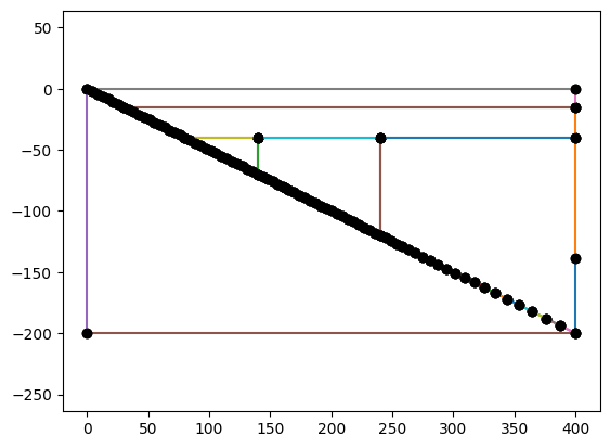
To demonstrate the subduction zone geometry we first need a slab so we once again describe the simplified straight slab from the benchmark with a lower crustal depth lc_depth = 40.
if __name__ == "__main__":
    resscale = 5.0
    # points in slab (just linear)
    xs = [0.0, 140.0, 240.0, 400.0]
    ys = [0.0, -70.0, -120.0, -200.0]
    lc_depth = 40
    slab = create_slab(xs, ys, resscale, lc_depth)
For demonstration purposes we have once again set a rather lower resolution resscale = 5.0.
For the remainder of the geometry, in the benchmark cases we do not include a coastline or any extra width beyond the slab so coast_distance = 0 and extra_width = 0. The subduction zone “type” is continental (sztype = "continental"), which means we need to set an upper crustal depth, which in the benchmark is 15km, uc_depth = 15. We have also already set the lower crustal depth, lc_depth = 40.
if __name__ == "__main__":
    coast_distance = 0
    extra_width = 0
    uc_depth = 15
    lc_depth = 40
    sztype = 'continental'
The input/output depth varies between the isoviscous (case 1) and nonlinear (case 2) benchmarks. We choose the value from case 1 here.
if __name__ == "__main__":
    io_depth_1 = 139
Leaving all other parameters as their default values we can now instantiate a subduction zone geometry object.
if __name__ == "__main__":
    geom = create_sz_geometry(slab, resscale, sztype, io_depth_1, extra_width,
                              coast_distance, lc_depth, uc_depth)
And examine it to see if it looks correct.
if __name__ == "__main__":
    if MPI.COMM_WORLD.rank == 0:
        fig = geom.plot(label_sids=False, label_rids=False)
        fig.savefig(output_folder / "sz_geometry_benchmark.png")
The finished geometry object can now be used to generate the mesh we will use to solve our numerical problem. To do this we are using GMsh in the background.
if __name__ == "__main__":
    mesh, cell_tags, facet_tags = geom.generatemesh()
Once the mesh (mesh) and mesh tag objects (cell_tags and facet_tags) are generated we can visualize the resulting unstructured triangular mesh.
if __name__ == "__main__":
    plotter_mesh = utils.plot_mesh(mesh, tags=cell_tags, gather=True, show_edges=True, line_width=1)
    utils.plot_geometry(geom, plotter=plotter_mesh, color='green', width=2)
    utils.plot_couplingdepth(slab, plotter=plotter_mesh, render_points_as_spheres=True, point_size=10.0, color='green')
    utils.plot_show(plotter_mesh)
    utils.plot_save(plotter_mesh, output_folder / "sz_geometry_benchmark_mesh.png")
It’s also possible to output the geometry to file using:
if __name__ == "__main__":
    filename = output_folder / "sz_geometry_benchmark"
    geom.writegeofile(str(filename.with_suffix('.geo_unrolled')))
Warning : Gmsh has aleady been initialized
Demonstration - Alaska Peninsula#
Once again the benchmark geometry is not very interesting so we also demonstrate the create_sz_geometry function on a more interesting case from the global suite, “01_Alaska_Peninsula”. First we can examine the parameters.
if __name__ == "__main__":
    if MPI.COMM_WORLD.rank == 0:
        szdict_ak = allsz_params['01_Alaska_Peninsula']
        print("{:<35} {:<10}".format('Key','Value'))
        print("-"*100)
        for k, v in szdict_ak.items():
            if v is not None: print("{:<35} {}".format(k, v))
Key                                 Value
----------------------------------------------------------------------------------------------------
coast_distance                      260
extra_width                         20
lc_depth                            35
io_depth                            185
uc_depth                            15
dirname                             01_Alaska_Peninsula
As                                  40.0
qs                                  0.065
A                                   52.2
sztype                              continental
Vs                                  59.0
z0                                  0.8
z15                                 0.4
xs                                  [0, 68.2, 154.2, 235.0, 248.0, 251.0, 270.0, 358.0, 392.0]
ys                                  [-6, -15.0, -35.0, -70.0, -80.0, -82.5, -100.0, -200.0, -240.0]
noting that in this case coast_distance and extra_width are non-zero, unlike in the benchmark case. “01_Alaska_Peninsula” is still a “continental” case however so we expect a geometry with two crustal layers.
We can define the geometry, once again using a low resolution resscale=5.0 for demonstration purposes.
if __name__ == "__main__":
    resscale = 5.0
    slab_ak = create_slab(szdict_ak['xs'], szdict_ak['ys'], resscale, szdict_ak['lc_depth'])
    geom_ak = create_sz_geometry(slab_ak, resscale, szdict_ak['sztype'], szdict_ak['io_depth'], szdict_ak['extra_width'],
                                 szdict_ak['coast_distance'], szdict_ak['lc_depth'], szdict_ak['uc_depth'])
and plot the resulting geometry
if __name__ == "__main__":
    if MPI.COMM_WORLD.rank == 0:
        fig_ak = geom_ak.plot(label_sids=False, label_rids=False)
        fig_ak.savefig(output_folder / "sz_geometry_ak.png")
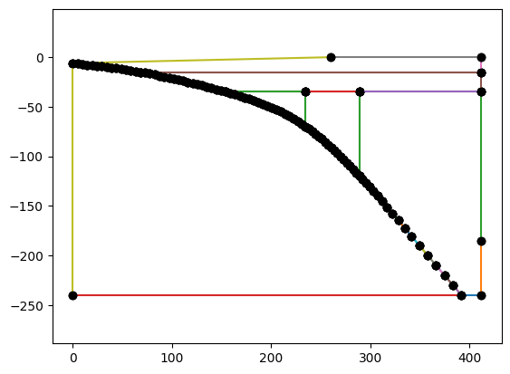
where the coastline and extra width are visible. We can now generate the mesh, visualize it and save it.
if __name__ == "__main__":
    mesh_ak, cell_tags_ak, facet_tags_ak = geom_ak.generatemesh()
Warning : Gmsh has aleady been initialized
if __name__ == "__main__":
    plotter_mesh_ak = utils.plot_mesh(mesh_ak, tags=cell_tags_ak, gather=True, show_edges=True, line_width=1)
    utils.plot_geometry(geom_ak, plotter=plotter_mesh_ak, color='green', width=2)
    utils.plot_couplingdepth(slab_ak, plotter=plotter_mesh_ak, render_points_as_spheres=True, point_size=10.0, color='green')
    utils.plot_show(plotter_mesh_ak)
    utils.plot_save(plotter_mesh_ak, output_folder / "sz_geometry_ak_mesh.png")
if __name__ == "__main__":
    filename = output_folder / "sz_geometry_ak"
    geom_ak.writegeofile(str(filename.with_suffix('.geo_unrolled')))
Warning : Gmsh has aleady been initialized
Demonstration - N Antilles#
We can also test create_sz_geometry on an oceanic-oceanic subduction case, “19_N_Antilles”. First examining the parameters.
if __name__ == "__main__":
    if MPI.COMM_WORLD.rank == 0:
        szdict_ant = allsz_params['19_N_Antilles']
        print("{:<35} {:<10}".format('Key','Value'))
        print("-"*100)
        for k, v in szdict_ant.items():
            if v is not None: print("{:<35} {}".format(k, v))
Key                                 Value
----------------------------------------------------------------------------------------------------
coast_distance                      185
extra_width                         19
lc_depth                            30
io_depth                            172
dirname                             19_N_Antilles
As                                  40.0
Ac                                  90.0
A                                   85
sztype                              oceanic
Vs                                  17.6
z0                                  0.5
z15                                 0.25
xs                                  [0, 50.0, 102.2, 166.0, 176.5, 179.0, 195.0, 271.0, 301.0]
ys                                  [-6, -15.0, -30.0, -70.0, -80.0, -82.5, -100.0, -200.0, -240.0]
we can see that this case is “oceanic” and hence doesn’t specify an upper crustal depth, uc_depth.
We can define the geometry, once again using a low resolution resscale=5.0 for demonstration purposes.
if __name__ == "__main__":
    resscale = 5.0
    slab_ant = create_slab(szdict_ant['xs'], szdict_ant['ys'], resscale, szdict_ant['lc_depth'])
    geom_ant = create_sz_geometry(slab_ant, resscale, szdict_ant['sztype'], szdict_ant['io_depth'], szdict_ant['extra_width'],
                                  szdict_ant['coast_distance'], szdict_ant['lc_depth'], szdict_ant['uc_depth'])
and plot the resulting geometry
if __name__ == "__main__":
    if MPI.COMM_WORLD.rank == 0:
        fig_ant = geom_ant.plot(label_sids=False, label_rids=False)
        fig_ant.savefig(output_folder / "sz_geometry_ant.png")
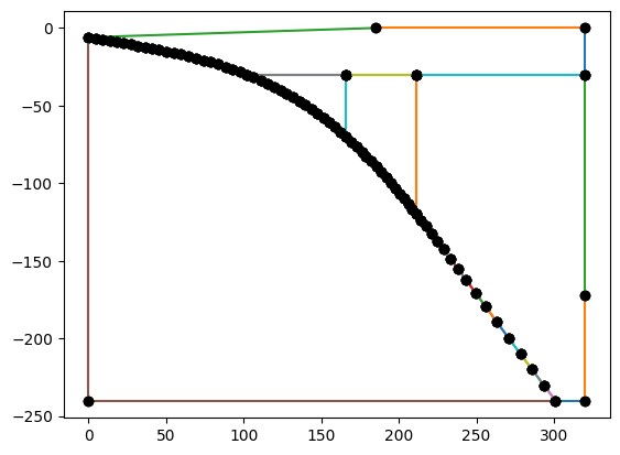
where the coastline and extra width are visible. We can now generate the mesh, visualize it and save it.
if __name__ == "__main__":
    mesh_ant, cell_tags_ant, facet_tags_ant = geom_ant.generatemesh()
Warning : Gmsh has aleady been initialized
if __name__ == "__main__":
    plotter_mesh_ant = utils.plot_mesh(mesh_ant, tags=cell_tags_ant, gather=True, show_edges=True, line_width=1)
    utils.plot_geometry(geom_ant, plotter=plotter_mesh_ant, color='green', width=2)
    utils.plot_couplingdepth(slab_ant, plotter=plotter_mesh_ant, render_points_as_spheres=True, point_size=10.0, color='green')
    utils.plot_show(plotter_mesh_ant)
    utils.plot_save(plotter_mesh_ant, output_folder / "sz_geometry_ant_mesh.png")
if __name__ == "__main__":
    filename = output_folder / "sz_geometry_ant"
    geom_ant.writegeofile(str(filename.with_suffix('.geo_unrolled')))
Warning : Gmsh has aleady been initialized
With the geometry (and mesh!) untested but demonstrated, it’s possible to move onto describing the physical problem we want to solve.
Finish up#
Convert this notebook to a python script (making sure to save first)
if __name__ == "__main__" and "__file__" not in globals():
    from ipylab import JupyterFrontEnd
    app = JupyterFrontEnd()
    app.commands.execute('docmanager:save')
    !jupyter nbconvert --NbConvertApp.export_format=script --ClearOutputPreprocessor.enabled=True sz_geometry.ipynb
[NbConvertApp] Converting notebook sz_geometry.ipynb to script
[NbConvertApp] Writing 19772 bytes to sz_geometry.py